Annual
Meeting
FIELD
TRIP
Saturday
- November 6, 2004
10 a.m. - 5 p.m.
ROADSIDE
GEOLOGIC DISCOVERIES IN THE ESTES PARK REGION
 A
one-day field exploration of topics in geology, hydrology, and geomorphology,
emphasizing earth processes and resources and their impacts on human settlement,
activities, dangers, and inspirations — led by Jim Cole (Ph.D.), USGS-Denver,
co-author of Geologic Map of Rocky Mountain National Park and Vicinity, Colorado
(USGS Map I-1973).
A
one-day field exploration of topics in geology, hydrology, and geomorphology,
emphasizing earth processes and resources and their impacts on human settlement,
activities, dangers, and inspirations — led by Jim Cole (Ph.D.), USGS-Denver,
co-author of Geologic Map of Rocky Mountain National Park and Vicinity, Colorado
(USGS Map I-1973).
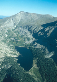
Aerial view of Hagues Peak and Lawn
Lake in the Mummy Range in 1976. The Lawn Lake dam (built about 1905), visible
at the lower right, catastrophically failed in 1982, sending a wall of water
down the narrow alpine valley toward Horsehoe Park. Several campers lost their
lives in the flood. Farther downstream, in Estes Park, water from the breeched
dam caused the Big Thompson River to rise over its banks, causing extensive
property damage to commercial areas of the city. Photograph by Jim Cole.
The spectacular alpine scenery of the Estes Park valley and Rocky Mountain
National Park reflect the sum of geologic processes operating over nearly 2
billion years. Roadside locales and vistas afford numerous opportunities to
explore aspects of geology, hydrology, geomorphology, and history that have
contributed to the geologic story of the region. These landscapes have affected
human activities in the past and will continue to influence us in the future.
Topics planned for this excursion include:
- Uplift and erosional history of the Front Range, and why mountains exist.Silver
Plume Granite — where it came from, how it got here, what it did along
the way (and what does it have to do with Lumpy Ridge?).
- The oldest rocks of the Front Range — unraveling their stories of deposition,
folding, metamorphism, and melting.
- Big Thompson flood of July 1976 — why did it happen, what did it do,
and what does "hundred-year flood" mean, anyway?
- Colorado — Big Thompson Project — moving lots of water under the
Continental Divide for lots of reasons.
- Glaciers, glaciation, and climate change in the last 2 million years.
- Roaring River debris fan and other effects of the catastrophic Lawn Lake
dam failure.
The field trip will cover a subset
of these topics based on weather, accessibility, and interests of the trip participants.
All stops will be along roadways and will require only limited walking. Box
lunches provided.
Back
to annual meeting main page
A Photo
Gallery:
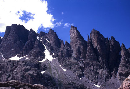
Rock spires along the Continental Divide,
near Bear Lake, in Rocky Mountain National Park. Vertical fractures have been
enhanced by frost action and weathering during Quaternary ice ages. Horizontal
banding shows light-colored granite intruded into metamorphic rocks. This
is a popular rock-climbing area. Photo by Jim Cole in 1971.
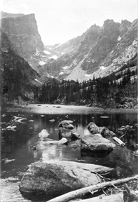
Looking up the glacially carved
gorge from Dream Lake, in Rocky Mountain National Park. Photograph by W.T. Lee
in August 1916. U.S. Geological Survey Photographic Library.
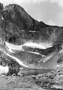
Precipitous cliff walls
of the east face of Longs Peak, as viewed from Chasm Lake, some 2,400 feet
below the summit of the mountain. At 14,255 feet, Longs Peak is the highest
peak in Rocky Mountain National Park. It is a prominent landmark visible from
Denver and the surrounding Great Plains. Photograph by W.T. Lee on July 22,
1916. U.S. Geological Survey
Photographic Library.
Back to top
Back to annual meeting main
page
Please contact Lisa Pinsker at lmp@agiweb.org
if you have anything to add to this page.